This app puts all the places on the world map that have a Wikipedia page.
wikishootme to know everything about the area. Better yet, use wikishootme like a real Pokemon Go map.
You think you know your area very well, but I’m willing to bet there are a lot of things that you don’t know – something that happened some time ago, or a remarkable building or park. Today there is a very easy way to find out everything or almost everything about a particular area, something like the game Pokémon Go, but for real life.
wikishootme to know everything about the area
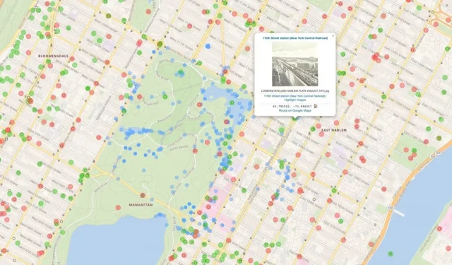
This app is called wikishootme.toolforge.me. Despite the rather strange name, wikishootme is a very good site. This is a world map based on OpenStreetMap and Leaflet with a small twist: it highlights nearby places that have their own page on Wikipedia, Wikimedia Commons, or Wikidata images. Thus, in practice, everything you can learn about any place near you is indicated on this map.
If you click on the icon with three layers in the top right corner, you can manage the different categories that appear on the screen:
- Wikidata (with image, max 3K): Shows places where there is a Wikidata page with an image.
- Wikidata (no image, max 3K): Shows locations that have a Wikidata page without an image.
- Commons Images (max 500): Shows locations associated with Wikimedia Commons images.
- Wikipedia (max 500): Shows places that have a Wikipedia entry.
- Mix’n’match (max 5000): Shows points using the Mix’n’match tool to link data to Wikipedia articles.
- Mix’n’match large directories (max 5000): shows points using the Mix’n’match tool for large directories.
- Flickr: Shows location images on Flickr.
You can display everything on the screen, but the more you have, the richer the map becomes. The best combination to use is probably Commons and Wikipedia images. This way you’ll find places that are popular enough to have their own Wikipedia articles, as well as places that have pictures on Wikimedia Commons.
But what’s really cool about the Commons option is that you can find images that aren’t recent. You can find historical photographs showing what this place was like at such and such a time. Very, very interesting. The first place you can visit with this map is your neighborhood and, more generally, your city. Be careful, we get lost quickly.
Use wikishootme as a Pokemon Go map for real life
But if you want to go even further, you can use wikishootme like a real Pokémon Go. TikTok creator deepsofwikipedia came up with this idea in her wikishootme video. If you enable the Wikidata (no images) category, you will see all nearby locations that have Wikidata but no images. You can go out, take a photo of the place, submit it yourself and turn on the green dot.
To do this, first create a Wikimedia Commons account and then upload your image. Then click on the corresponding red dot on the map, click on the hyperlink in the name of the place, scroll down the Wikidate page, select “Add statement”and then “image”. Enter the filename of the image as listed on Wikimedia Commons, then click Publish. If you don’t know what to do, go take pictures and replenish the database with your friends!
Leave a Reply